
Zoning 101: Regulating land Use
What is Zoning?
Zoning is the set of rules that tell you what you can or cannot do with land in the city of Milwaukee. It includes both a written document of rules and a map that shows what zone each piece of land is part of.
By the early 1900s, the boundaries of the City of Milwaukee were approximately Capitol Drive to Oklahoma Avenue and Sherman Boulevardt to Lake Michigan. Much of this area had been developed without any rules. Officials decided that the city needed rules to better plan for the city’s future development. In 1920, Milwaukee adopted its first Zoning Code.
Zoning in Milwaukee
- 1920 – The City of Milwaukee created its first Zoning Code and Zoning Map (see image)
- 1951 – A new Zoning Code with more regulations
- 1960s – Newly annexed areas zoned for low densities
- 1985 – Updates made to the 1951 Zoning Code
- 2002 – A new Zoning Code & Zoning Map was adopted
- 2002-2022 – The Zoning Code text has been updated through ongoing technical updates. Periodically, more in-depth updates have been made based on Comprehensive Plan recommendations.
- 2025 – After two years of engagement, the Housing Element of Milwaukee’s citywide comprehensive plan was adopted. This set the direction for housing-related updates to the Zoning Code.
In the past, zoning has been used to exclude more affordable housing types and the people who live in them from certain neighborhoods.
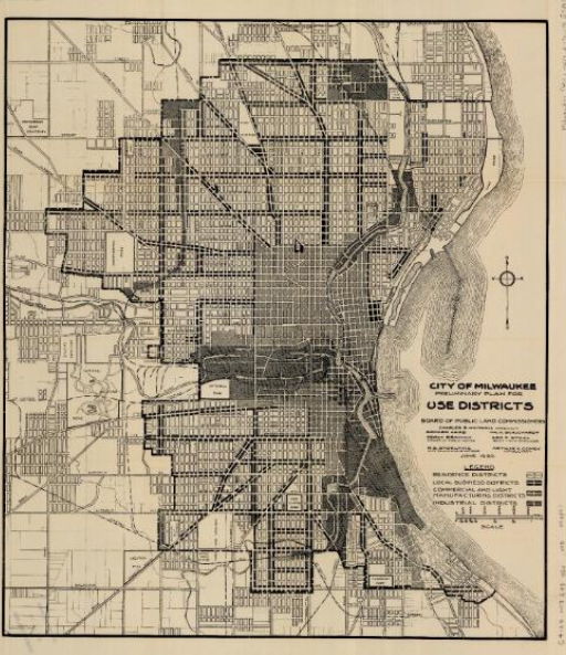
Image: City of Milwaukee's first Zoning Map
Zoning regulations attempt to answer a few big questions about development in the city:
- What type of activity can happen on a property? (Land Use)
- Where in the City can those activities happen? (Zoning Districts)
- How much space can that activity take up? (Bulk Standards)
Land Use: What types of activities can happen on a property?
Land use describes how a property is used.
- Residential Uses: Places to live such as houses, apartments, etc.
- Commercial Uses: Places to work and shop such as stores, offices and restaurants etc.
- Industrial Uses: Places to work and produce or store goods like factories and warehouses.
- Educational & Community-serving Uses: Places to learn or gather in the community such as schools, libraries, places of worship, etc.
- Entertainment and Recreation Uses: Places to play and enjoy time with others such as parks, festival grounds, sports centers, and theaters.
- Mixed-Uses: Places to do a combination of these things like mixed-use apartments with commercial on the ground floor.

Zoning Districts: Where can those activities happen?
A Zoning District is an area on the Zoning Map where certain land uses and building types are allowed. Not every land use is allowed everywhere.
The Zoning Map shows which zoning rules apply to each property.
Zoning districts:
- Group land based on similar land uses and building forms
- Have associated written rules that guide land uses and sizes/shape of buildings
Zoning districts organize Land Use to:
- Manage the burden on shared resources like transportation and public utilities.
- Reduce conflicts between different types of uses. For example, heavy industry may impact the health and safety of nearby residents.
- Give residents and businesses clarity of how properties can be used now and in the future.
The Housing Zoning Code Tune-up is only tuning up the written rules for the zoning districts. The Zoning Map is NOT changing.
Bulk Standards: How much space can that activity take up?
Each zoning district has a unique set of rules that guide the shape of a development on a property.
Bulk standards are rules that help determine the size and shape of buildings and the land they sit on.
This creates buildings of different size, shape, and placement. Examples are included below.
Size and Shape
The illustration below shows a 5-story mixed-use building. The Zoning Code limits this building’s shape because it cannot be taller than 5 stories.
The illustration below shows how single-family home is limited in its placement on a property by side setbacks, a front setback, and a rear setback. Placement of a home on lower-density residential properties is also limited by maximum lot coverage. Lot coverage is how much space the footprint of a building takes up on a property.
More details on bulk standards are available under Density & Bulk Standards and under the Lot Standards sections.
Why guide building size, shape, and placement?
Zoning standards help to manage shared resources including:
- Natural light
- Fresh air flow
- Storm runoff
- Open space / sense of space
- Room for public services (e.g., utilities and access)
Zoning standards also help balance relationships between surrounding buildings:
- Preserve neighborhood consistency
- Protects privacy
- Reduce shadows and enhance public safety


